
I looked long and hard unable to find any current, reliable information on this section of the Ozark Trail. It starts at the south end of Middlefork at hwy J through some of the most rugged ozark hills we have. I doesn't sound that crazy hard at 29 miles one way but after taking the plunge today, I can offer up a current point of view. I'll start by saying that this is not the trail for OT virgins. Start with North Trace or Middlefork. NOW, if you dig the challenge of staying upright or dying, climbing until your head explodes, seeing one of the moar amazing bluff trails in the mid-west and rock gardens that are tough but rideable, then head a little further south.
The drive takes about 20 minutes longer than going to 32/DD for MF. The ride starts with a creek crossing that we got across with dry feet followed by a few hundred feet of creek debris(big rocks). Soon the trail starts up a 3/4 mile climb on your first section of the mostly bench-cut Karkaghne, you must call it by name or it will get you. Seriously, 85% of this trail is bench-cut into steep hillsides. The north part from J down to Sutton Bluff campground was built about 10 years ago and much of it was constructed using machinery. This cuts a wider base that seems to hold up well against the forces of nature and allows you to rip when pointed down, moar resembling MF. The south end was built back in the 80's and tends to be much narrower although some of the north end is fairly narrow also.
Middlefork climbs about 125' per mile, Council Bluff about 80' per mile, Berryman about 95' per mile. The Karkaghne climbs almost 150' per mile. This doesn't sound like much, but try it and you will see. You may do as you wish but IMO this is not a single speed friendly trail, go ahead and call me a puss. I almost twisted my carbon bar into a knot trying to grab another gear that I didn't have. Long ass climbs that are above 15% for a lot of the time but with gears they are rideable. You don't fly through this trail like MF as hard as you can push a gear. There are many rock gardens that will challenge anyone to go dab free. The carnage from the Derecho,( ENGLISH: NOUN: PRONUNCIATION: deh-RAY-cho) in 2009 is a sight to see just as much as it will disturb you and at first, make you sick to your stomach. There are LONG sections where 95% of the trees are gone. I saw an estimate saying over 2000 trees had fallen crossing the trail surface on the Karkaghne alone, when we finished there were only three that require a dismount. Not that we cleared much in comparison but using a handsaw, we removed 20 or so that would have brought you to a stop. Lots of holes left behind from the root balls, Syllamo style, but only 3 or 4 that aren't rideable and apparently they are working to repair all of them as you read.
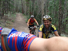
After you descend 1/2 mile into Sutton Bluff camp ground on the pavement and cross the Black River the trail makes an immediate left only feet after the bridge. This is when your jaw and face will start to get sore. A couple of quick dismounts on some steps up and then back down will lead you to the base of a massive climb with 7 switchbacks. We could not ride the first two but made the rest, with a "rest" in the middle, or two. After the switchbacks you head out onto the bluff. I know many of you have ridden the bluff trail at the ranch, this thing is like that on steroids and crack at the same time! Merely walking this section will make anyone pucker let alone riding it and it is rideable. Make sure you stop and enjoy the view, it's amazing! Huge cliff walls above you and an almost sheer 200' drop below you. Your jaw will hurt because of all the dropping and you won't be able to stop smiling hence the sore face. Moar climbing and descending on very narrow bench-cut from here to the hollow that drops you down to Bee Fork which is like a small river and was our turn around point. 14 1/2 miles to this point which took us 3:15. While we did stop a bunch to move/cut stuff, this was the toughest 3 hours I've had in a while. We could not see a way to cross Bee Fork without getting soaked but we think there is a spot up stream that may be passable.
Now shame-the-hell-on-me for not taking a camera but I'll just have to go back and get proof. It snowed on us off and on for the first 3 hours and was between 19 and 26 degrees which may have contributed to our difficult labors. The bummer and harsh reality of the Karkaghne is that it is likely to be a November through April only trail as it will be a jungle come summer.
Here are some nice maps broken down into three sections.
North
Middle
South
Here is my Garmin link in my continuing effort to "map the world" as Tom Albert puts it.
*EDIT* The only other suggestion I would have is look at the maps or have one with you before you head out. One common report I kept getting when looking for information was that it was a difficult section to follow and you could easily get lost. We had no trouble at all but I had a good picture of where we should be in my head and we watched for OT signs. The only place we did not see any was just before Sutton Bluff when you pop out on the road you descend on the pavement all the way to the river. You can easily miss the trail after you cross the bridge so watch for it. It's well marked when climbing back up on your return trip. The Sutton Bluff trail head has a small loop that connects it to the bypassing trail. If you go the wrong way it will just take you back to where you need to be, just drop down the steps with the handrail.
There is also an unmarked connector at the one mile mark that comes up from the Brushy Creek trail head so skip that. My guess is that would be the place to park if the first creek was too deep to cross. Soon after you will see a single track that crosses your path with green arrows marking it. Not sure what this trail is but just follow the OT signs and you'll be fine.
Subscribe to:
Post Comments (Atom)


5 comments:
Good to see ya out explorin'.
GOOD info. will be referencing that in the future.
-CFR
The Destroyers have been chompin' at the bit to ride the Karkaghne. You may have ridden the trail first but I doubt you did it with more style or panache...you probably weren't born a jackass either.
I wish I could post useful things like this on my blog but I've decided I hate people. It will be a cold day in hell before I provide any tricks and tips for free on my blog. Maybe I'll come around some day. More power to you.
I have a feeling this thing is remote enough that this simple obstacle will weed out the weak. Maybe not born one but have been know to morph into one on occasion.
At least you'll have a moar clear trail to ride now that we've worked on it for you.
Thanks Mashor for the beta on this trail. I was dumb enough to ride it on SS, despite your recommendation.
For those who find this post, here is moar info: http://www.gorctrails.com/board/topic.asp?TOPIC_ID=7768
Post a Comment