Tuesday, April 5, 2011

A weekend at Council Bluff Lake

The weather looked perfect for a two night camping trip in the Ozarks. The campground at Council Bluff Lake had just opened and the camping was free coinciding with the ceremony and completion of the John Roth Memorial site along with the official renaming of Middle Fork to Middle Fork-John Roth Memorial Trail. With little time to get ready, we took the guy approach, got everything together and stopped at the store to pick up what we didn't have on the way out. This of course leads to impulse buys like chips, little chocolate donuts........Non the less, we were on the road.

We arrived a little after dark, found a spot near the Ozark Trail Association group site and were set up in a flash. Adam settled on a log cabin style and built our fire using only things found around the site and started it with his fire starter that he got for Christmas. He had never used it before so this was prime time to get comfortable with it. It's one of the two piece ones with some kind of flint rod and a striker. With only the help of some dryer lint that we carry in our backpacks, he got it going. They had just done a prescribed burn of the entire campground so small tender was a little hard to find. We sat around the fire in the cool air and soon it was smores time. I'm not a fan but it's fun watching Adam and Eric make and eat theirs. Soon it was off to bed and with the temps dropping, there was little fuss from them.

Up early the next morning we stoked the fire and made some oatmeal to warm us up. Chased the oatmeal with the donuts. Had to have energy on tap for the long day ahead. It warmed up fast so we changed into our shorts and got our daypacks ready as the OTA shuttle would be ready to take us over to the DD/32 parking lot for the ceremony soon. John's wife had chartered a school bus to bring around 40 people down including his kids along with his mom and dad. I'd guess there were 100 to 120 people there from OTA members to the US Forestry to you name it. It was a perfect day for it.


When the ceremony was over we figured there would be a flood of people trying to get back to CB for the lunch that was to be served so I asked the kids if they wanted to hike back instead. They were up for it so we took off to hike north on the MF/JRM.

They couldn't comprehend the force it must have taken to move this bridge free of its concrete base down the creek.

We made it to the intersection of South Trace and MF/JRM.

Adam and Eric rounding a switchback on South Trace.

There is a cool spring that runs pretty much year round and even in winter, has green vegetation.

Soon we were at the connector that would take us over to the Council Bluff loop. Note the horses prohibited sign, we saw plenty of post holes on this section.

We hiked up to the campground to catch some lunch and take a short break. We had been looking for cool rocks and Adam wanted to go look some more so we headed back down to continue our hike. On the first leg of our hike you'll notice Eric is walking with a trekking pole, Adam's trekking pole to be exact. What a good big brother! We were also on the hunt for a fallen stick that Adam could carve up to have a walking stick for himself and we found one. He removed the bark and any rough spots with his pocket knife and then I carved his name in it. The small "knick" is for its first camping trip, more to follow.

Stopped on the foot bridge at the intersection of the lake loop and the connector.


A few pics from the lake loop, I don't think they had any idea how big the lake actually was!


Soon we were at the climb back up to the campground after some rock hunting in the nearby creek. The hike, about 6 miles, was no problem for Adam but it was Eric's first big hike and he did great!

We had dinner as soon as we got back. Adam started the fire from scratch again, this time he was a pro and it only took a few tries. We stopped by the memorial on our way out Sunday morning so we could actually read and enjoy it.

I took close ups of the plaque so I can send them to you if you want to read it, but I'd suggest you head down and read it for yourself!

Tuesday, March 29, 2011

Nate, Brian. Brian, Nate.

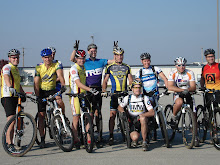
Those were some of the first words I spoke when we arrived at Bass' River Resort on that Sunday morning. Brian and Nate had never officially met. I knew them both well and had no worries about the trip. Nate and I originally started talking about something like this months ago. Planning it for Saturday the last weekend in March was a shot in the dark with the weather, but I thought rain would be our major obstacle, not inches of snow and freezing temps. The forecast Saturday forced us to put the trip off for a day. It was that or potentially not go at all and if there was any possibility at all, that wasn't going to happen. I talked to Nate Saturday night and told him that Brian and I were going, he was on the fence but just needed a little nudge.

We arrived at Bass' at a little after 8 a.m. to much less snow than Columbia and St. Louis had when we left. After the introductions and few chest bumps, we were ready to head out. I was nervous, fo sho. I had a plan that in good conditions would be tough. Ride the gravel over to the Berryman and head straight south on the Ozark Trail, traveling on much of the Courtois(pronounced: Code away)section, at Hazel Creek Campground the North Trace section begins, at hwy DD the South Trace section begins which we would ride 2 or 3 miles of and then take a right turn on the Middlefork section ending our ride about 7 miles later at a campsite in Wolf Pen Hollow. We did all of that with one exception. We turned onto hwy DD and skipped about 4 miles of trail. The iffy conditions up around Hazel Creek had slowed us down and sapped us of precious energy. So to keep from setting up our camp in the dark, we made this decision. I will say this, when we left, I had no intentions of making it to our destination. I just didn't think it would be possible. We all had a few extra pounds of gear due to the temps, possible trail conditions and the forecast for snow that night.

It was clear that we had all given this trip the respect that we felt it deserved. Everyone had their gear together and very few adjustments had to be made on the ride. I've been on regular rides where there is that one person that constantly has issues and slows the whole group down. We were a tight group all day. We all made some clothing adjustments when we got to the Berryman trail entrance and we were off.


As you can see, there was some snow on the trail, but not too much. Most of the falling snow had melted from the exposed ground of the trail and hung around only on the leaves leaving us with great trail to explore. We were all very surprised at how well we could ride with all the gear on our bikes and our stuffed packs. My bike is heavy to begin with at close to 30 pounds. With my gear, extra tubes, full water bottle and a front fender it was right at 45 pounds. Would have been an issue if everyone else had normal rides, but we were all in it. Nate is the light weight of the bunch and probably did the best job of packing for the trip so he would toy with us on the climbs. He won't say he was, but he was riding at our pace and could have ridden away from us at any time. All was going great. We came to one of the new reroutes on the Berryman and decided to take it. I don't think it's officially open but it was the right choice. When finished, it will eliminate several muddy sections, long sections where the trail has become the watershed and is simply a creek bed now along with the section where I crashed last year. Almost 100% benchcut single track awaits you. Lots of armouring specifically near one of the creek crossings, it's very cool. It appears to me that this reroute will add some length to the Berryman loop as it heads way up into one of the valleys that the old trail just passed by. It was in this section that I noticed some tire sealant spraying from my front tire. A knife like rock had gone right in the tread area of my tire so I pulled out my little tire plug kit, dislodged the rock and plugged it. The sealant stopped the airflow but it was a big cut so I added a second plug and away we went never to have an issue with that tire again.
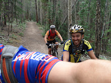
Soon we were finished with the trail that is shared with Berryman and on our way south on the OT. I rode ahead knowing a prime photo op was nearing.

We crossed hwy 8 and came to the Lost Creek crossing that we knew would be deep and would probably require this:

Shoes back on, no whining and we were off again. That next climb is a bitch! I stopped to take a shot a little while later of Nate just ahead of me on a section of trail where I swear they just got tired and gave up on normal trail building rules as it is crazy steep on both sides. Really I just needed a break.

Only notable thing from here until lunch was that some pricks had ridden the trail on motorcycles and did some damage to the trail which was making it tough for us. The ruts they cut were holding the melted snow and making it a slow go for us. If it's dry, motorcycles can do wonders for a trail but they had no business being on that trail when it was that wet. Soon we stopped at Hazel Creek Campground for lunch taking advantage of the good water source and picnic tables. Not sure why I didn't snap a pic, guess I was a little out of it?

After about an hour lunch we headed south on the North Trace section of the OT hoping the motorcycles hadn't, they had. We pressed on to Hazel Creek which in the past has been too deep to ride across but to our relief, was ridable. Within minutes we rode by the tree that the swarm of hornets came out of last year and attacked me, no hornets on this 38 degree day. After a while we came to Martin Road. We stopped for a breather and then I led us out from there, no more motorcycle tracks! Wohoo! Trail was firm, fast and dry, amazing! I soon started to have some bizzaro drivetrain noises and decided to do an on trail diagnosis. Separated chain link. Whipped out the tool chest and had her up and running before Nate could finish his Tiger Milk bar.

We were all getting tired so I presented Nate and Brian with an idea. I really wanted to make it to the campsite on Middlefork but knew we were running out of time and our legs were feeling a little like, well, we had ridden 7 hours on really heavy mtbs. So when we finally climbed up to the end of North Trace at hwy DD we turned right and bypassed a few miles of trail to get to the DD/hwy 32 parking lot quicker and easier. Saved us probably 20-25 minutes but we were going to make it and still had some tough riding to do this late in the game. Soon we were there! My goal was 6 p.m. and we arrived at about 6:15, not bad. It felt good, great! Gathered firewood, set up tents and started cooking some food. The waterfall was running strong and the firewood was dry enough to get a fire going with only a little tender that I brought along. Only after my belly was full did I think about taking any pics.

Then I asked Nate how he felt.

At about 10 it was cold and we decided to call it a night. It was easy to sleep, for me anyway. Had to get up once in the night to find a fresh snow on the ground and still falling, EPIC! Planned to get up early, slept until almost 8!


It was tough to get going that morning. Knowing that we had to pack all our stuff back up and then ride back was a little daunting. Collectively, we had already come to the realization that riding the trail all the way back wasn't going to happen. This was one of the reasons I picked this route for our trip, there were many, many ways to short cut. We were finally ready, the warm sun had melted away all the snowfall from the night and we had a clear trail ahead of us.

10:15 and we were rolling, about 2 hours later than we talked about leaving. After only minutes of riding, I could tell the slow leak I had been nursing in my rear tire was going to need some attention or I would slow us down all day. I stopped and put a tube in and Nate added some air to his tire at the same time. I led out down the next hill and almost immediately his tire blew off the rim! I didn't hear it and climbed the next hill before I figured out they weren't behind me. I started back down when I saw them heading toward me on the other side of the valley so I stopped above a double switchback section for a pic.

We pushed on and finally got back to hwy 32 and went by the memorial site for John Roth, a very special individual whose efforts made this trip possible with his love and dedication to this trail system we call the Ozark Trail. He will be missed. The dedication and completion of the memorial is supposed to take place this weekend, but it is still impressive.

From there we headed north on DD, end to end all the way to hwy C. We all had enough food but I remembered that there is a small bait store at that intersection and started wondering if it would be open and it was. Without haste, we started grabbing stuff off the shelves. Nate and I had the nice fellow make us a salami and cheese sandwich then split a big bag of chips. It was as good for the mind and it was for the body. Sun was shining but the increased speeds on the roads made it feel cold so we all layered up. We left there traveling east on hwy C then turning left on hwy P. I knew that the gravel road used in the Berryman Epic eventually came all the way over to P but I wasn't sure exactly how far we had to go. I started to wonder if I had missed our turn but didn't give in to the doubt and Nate nor Brian questioned me. We rounded a corner and there it was! Only one short wrong turn and we were soon in recognizable territory, what a relief! We actually saw some course markers for the Berryman Epic still posted on trees. The climb back up to Berryman campground destroyed me and I think it did Brian also. Nate floated away in the distance but I think he had motivation in the form of a latrine!

A short break and we started out on our last stint of gravel that would take us all the way back to Bass'. There are a few monster climbs between Berryman and Brazil Creek that I didn't remember as it's been a long time since I've ridden that gravel. I sat up for one last pic knowing the end was near.

51 miles on the way out, mostly single track. Over 9 hours start to finish.
47.5 miles on the way back, mostly gravel and road. 5 1/2 hours start to finish.

Thanks to Brian and Nate for helping make this happen. I know this trip made me a stronger person.

Monday, February 28, 2011

Death by Hills gives new life

to this under-trained, overweight, lifeless lump. I had a blast as did the crap load of people that finished this year. Literally on the verge of cramping from Woodland Meadows to the end on each repetitive lashing, I somehow survived feeling okay. Awesome to see some new faces looking to conquer this thing. From ultra light, TDF lookin doodz to crazy strong nut cases like Nico on single speeds. From old veterans to Wendy, first time on road tires and in West County, nice freakin job!

Amazing the following this non-team team has. Only one casualty that I know of, I heard he just lost his........Momentum! No mechanicals that I saw, just a bunch of tough people making this point their Mecca.


Special thanks to C.F.R. who was riding like a man on fire at the very end.

Friday, February 18, 2011

It's about time(updated)

Went on an awesome road ride yesterday with C.F.R and Steve Friedman. I showed them something that a lot of cyclists know about, but moar don't than do. I showed them a monument out on Old Manchester that was dedicated in 1921 to Victor Smith. Anyone who thinks they are tough just needs to stop and think of what it must have been like to ride a bike back then. My guess would be wooden rims, single speed of course. Only choice was sew ups or maybe even solid tires. I often wonder what those riders would think if they could see us now. Could they ever have imagined what the sport has turned into? What would they think about society? What would they think about the relationship between cyclists and motorists?

Anyway, it bothered me how bad the growth had gotten out there. Hell, I knew where the stone was and had a hard time finding it. Since I didn't want to ride today I got the wild idea to go out and do something about it. I threw the chainsaw, loppers, handsaw, rake and a bunch of other stuff in the truck and took off. I stopped by the other known monument located at Pond and Old Manchester to take a picture. This one is from 1923, dedicated to William M. Butler.


I'd think the building, trees and all have changed. This photo is available for purchase from the Missouri History Museum. Went out and tried to stage a picture to see if the building or trees are still there. Today's condition is kind of a shame.


I had the forethought to take a picture of the condition it was in when I arrived.


Here is a photo I just found that I took last year in the spring.


After about 2 hours of cutting, lopping and dragging, I was satisfied.


If you look at Old Manchester as traveling east/west from 100 and Fox Creek Road, then it is just past Rem lane on the south or left side, about a mile west of 100.


Who would you dedicate a monument to? I can think of a few awesome people that have made a serious difference to our sport. Stop by and look at it. Hopefully this clearing will last a few years but I will not let it get this bad again, it deserves moar respect than that.

Wednesday, January 19, 2011

Too Much Time on My Hands


Well, not really. I just found this interesting and decided to take the time to see if anyone else felt the same. This is a dozen or so of my rides that I have recorded over time over-layed on Google Earth creating a picture of MOST of what I've ridden down there. When I say most I mean most because while I have ridden it several times, I have not recorded the South Trace from the Middlefork connection down to its end. That end not being the end of the Ozark Trail, but the end of mountain bike use, hence the creation of Middlefork. Middlefork allows all users to continue on with the flowy goodness of Mark Twain National Forest single track.

This map begins at the north only a handful of miles from the actual northern most point of the OT. Unfortunately, bikes are not allowed beyond this point on my map. In fact, I think we went just past the official Narrows trail head where you can access the Courtois section and begin riding south. It was a jeep trail but we did see the Huzzah signs which, I believe is where bike use ends. We rode in from Bass' River Resort and turned around to ride back.

From there to the southern end of my map is about 91 miles of single track, one way. Also in the top part of the map are the gravel roads used in the Berryman Trail Epic which can be used to bypass any or all of the single track between Bass' and Berryman. This section also contains the newest trail in the OT system.

After what I would call the first two "loops" when starting from the top, you make it to the Berryman. Only the west side of Berryman shares the dirt with the OT, but I thought the entire loop should be included. At this resolution, Berryman looks like one small loop and one very large loop when in fact it is one ginormous loop, 24ish miles to be exact.

Just below is another good sized loop that shows the OT on the left and a gravel return on the right. Under that, are two very small and one slightly larger loop which are all part of that gravel return. The OT only crosses the gravel two times here, but again at this resolution it looks like more.

From there it's all single track for a while, finishing the Courtois(Code-away) section at Hazel Creek camp ground and moving on to the Trace which is divided into a north and south section. North Trace ends at hwy DD where you have one mile until you reach the 1/4 mile long Tellock Connector(GORC had much to do with this re-route) which takes you over to Council Bluff Lake. A 12.5 mile loop around the lake with a 1/2 mile option up to the campground is in there. From the junction of South Trace and the Tellock, you keep going for a mile or so to the Middlefork fork. To its end, Middlefork is 24 miles. There is a large loop and a small loop in this section. These are the gravel returns that some like to use, I prefer the trail.

Just below the small loop is the start of the Karkaghne(Car-kag-knee), a 29 mile section and my newest addition to my map collection. The very bottom of my map is still about 14 miles short of completing this section so I have work to do.


While you can order up copies of any and all of these maps, these are my experiences. I've ridden all of this, in many cases LOTS of times. In some, only once. 117 miles of single track and 35 or so of gravel, it's a ton of fun. All of this within two hours of St. Louis and a ton of camp grounds available as well as camping on the trail itself. Beyond the south end of the Karkaghne is much more trail to be "mapped".

When I say they are my experiences, I really mean they are experiences I've had with friends. Some in races, others in non-races but all just riding to have fun. These are some of the Jerks that helped me create this collection.

Todd Hecht
Greg Ott
Jeremy Bock
Matt Grothoff
Dwayne Goscinski
Chris Ploch
John Pieffer
Nate Means +1?
Mike Best
Doug Davis

Friday, January 14, 2011

Bizarro Post

Not really sure why I feel like doing this. That is, exposing my fat, white underbelly on the web, so go easy.

I was just sitting at my computer and since no one else is home, I opened up my media player and started playing one of my newer finds over my inadequate space saving monitor mounted speakers. I will begin by saying that I don't claim to have "been there with this band since the beginning", I just discovered them last summer after the release of their 6th-ish album. I found them while watching stuff on You Tube, this linked me to that and holy crap, I found Avenged Sevenfold. This is a good tune but the video looks like somebody had too much time to play on their computer, kinda goofy-Buried Alive.

Keep in mind, I like these guys because they pour out an energy that I fail to feel in 99% of the music released in the last few years. I'm not that into the whole skeleton and bat wing thing, but these guys have a sound that is real. I watched one of the music award shows a while back and all I could do was hang my head and turn off the TV. The music out there right now sucks, at least what they say is popular. Some of you will say that these guys are pussys and they've sold out. Some will listen to it for 10 seconds, cover your ears, begin to cry and then repent. It's not like I'm listening to Nickelback or anything. I used to like Nickelback, they had an awesome, powerful sound(for about 10 minutes). It's what you do with that sound that defines you in the music industry. Nickelback went the wrong way in my opinion. That's what A7x did right. If you listen to some of their old stuff you will definitely hear a different band than the last 3 or 4 albums. They were loud, fast, screamed a lot and didn't care what you thought. BUT, hidden in their stuff, even back in the beginning is a twisty, melodic and rhythmic vein that other bands search for and never find. I believe they found it and went with it, hence their newer, albeit more profitable direction.

I rushed out and bought Waking the Fallen, City of Evil, Avenged Sevenfold and Nightmare. Cost me about $40 after tax. Best $40 I've spent in a while. I'm not big on downloading music, I'd rather have the CD in my hand. I feel musicians deserve my $10 for their effort.

I guess one of the reasons I thought I'd write this is that unless you know me, you probably don't know me. My taste in music would surprise most from the impression I tend to give, or lack there of. I'm a no tattoo havin, non-pot smokin, light drinker with a wife and two kids, a den leader in scouts, mountain bike racer that eats too much and I happen to like a HUGE range of music. A range so huge that I'm not going to talk about it for fear of persecution. (Not that there is anything wrong with any of the above, I just have moar fun building pinewood derby cars than getting high.)

A7x history lesson from me and I don't know a ton. They are from, surprise, southern California. A 5 member band, they started really young in 1999 but when they broke into the scene, they plowed it over. In 2009 their drummer, Jimmy"The Rev" Sullivan died of a combination of heart disease aggravated by years of drug and alcohol use. They had already started work on their newest album, Nightmare but hadn't recorded any of it. A well know metal drummer, Mike Portnoy that was the creator of the band Dream Theatre stepped up and played the rest of their tour so they wouldn't have to cancel a ton of shows. A7x asked Mike to record the new album with them and he did. He liked the direction A7x was going so much that he decided to put DT on hold, eventually quitting DT and now tours with them. He's not officially a member but he fills in pretty well. Personally I think Mike might be technically a better drummer than The Rev, but I like the energy The Rev bled into his songs, you could feel it.

Ultimately, I started my collection of A7x to listen to while racing but they have become one of my top choices. I'm a big Tool fan also, but if you check out the movie Blood into Wine, it gives you the feeling that Maynard may be done making new music. Worth the watch by the way. He now owns a vineyard in Arizona called Cadudeus Cellars. To the critics, his best wine goes by the name Judith but it's hard to get. Listen to the song that plays on the Judith page, be patient and wait for part two to start. It is one of my favorite Tool songs and the lyrics are down on the page, read them. This guy's no dummy.

Saturday, January 8, 2011

The elusive Karkaghne

I looked long and hard unable to find any current, reliable information on this section of the Ozark Trail. It starts at the south end of Middlefork at hwy J through some of the most rugged ozark hills we have. I doesn't sound that crazy hard at 29 miles one way but after taking the plunge today, I can offer up a current point of view. I'll start by saying that this is not the trail for OT virgins. Start with North Trace or Middlefork. NOW, if you dig the challenge of staying upright or dying, climbing until your head explodes, seeing one of the moar amazing bluff trails in the mid-west and rock gardens that are tough but rideable, then head a little further south.

The drive takes about 20 minutes longer than going to 32/DD for MF. The ride starts with a creek crossing that we got across with dry feet followed by a few hundred feet of creek debris(big rocks). Soon the trail starts up a 3/4 mile climb on your first section of the mostly bench-cut Karkaghne, you must call it by name or it will get you. Seriously, 85% of this trail is bench-cut into steep hillsides. The north part from J down to Sutton Bluff campground was built about 10 years ago and much of it was constructed using machinery. This cuts a wider base that seems to hold up well against the forces of nature and allows you to rip when pointed down, moar resembling MF. The south end was built back in the 80's and tends to be much narrower although some of the north end is fairly narrow also.

Middlefork climbs about 125' per mile, Council Bluff about 80' per mile, Berryman about 95' per mile. The Karkaghne climbs almost 150' per mile. This doesn't sound like much, but try it and you will see. You may do as you wish but IMO this is not a single speed friendly trail, go ahead and call me a puss. I almost twisted my carbon bar into a knot trying to grab another gear that I didn't have. Long ass climbs that are above 15% for a lot of the time but with gears they are rideable. You don't fly through this trail like MF as hard as you can push a gear. There are many rock gardens that will challenge anyone to go dab free. The carnage from the Derecho,( ENGLISH: NOUN: PRONUNCIATION: deh-RAY-cho) in 2009 is a sight to see just as much as it will disturb you and at first, make you sick to your stomach. There are LONG sections where 95% of the trees are gone. I saw an estimate saying over 2000 trees had fallen crossing the trail surface on the Karkaghne alone, when we finished there were only three that require a dismount. Not that we cleared much in comparison but using a handsaw, we removed 20 or so that would have brought you to a stop. Lots of holes left behind from the root balls, Syllamo style, but only 3 or 4 that aren't rideable and apparently they are working to repair all of them as you read.

After you descend 1/2 mile into Sutton Bluff camp ground on the pavement and cross the Black River the trail makes an immediate left only feet after the bridge. This is when your jaw and face will start to get sore. A couple of quick dismounts on some steps up and then back down will lead you to the base of a massive climb with 7 switchbacks. We could not ride the first two but made the rest, with a "rest" in the middle, or two. After the switchbacks you head out onto the bluff. I know many of you have ridden the bluff trail at the ranch, this thing is like that on steroids and crack at the same time! Merely walking this section will make anyone pucker let alone riding it and it is rideable. Make sure you stop and enjoy the view, it's amazing! Huge cliff walls above you and an almost sheer 200' drop below you. Your jaw will hurt because of all the dropping and you won't be able to stop smiling hence the sore face. Moar climbing and descending on very narrow bench-cut from here to the hollow that drops you down to Bee Fork which is like a small river and was our turn around point. 14 1/2 miles to this point which took us 3:15. While we did stop a bunch to move/cut stuff, this was the toughest 3 hours I've had in a while. We could not see a way to cross Bee Fork without getting soaked but we think there is a spot up stream that may be passable.

Now shame-the-hell-on-me for not taking a camera but I'll just have to go back and get proof. It snowed on us off and on for the first 3 hours and was between 19 and 26 degrees which may have contributed to our difficult labors. The bummer and harsh reality of the Karkaghne is that it is likely to be a November through April only trail as it will be a jungle come summer.

Here are some nice maps broken down into three sections.

North
Middle
South

Here is my Garmin link in my continuing effort to "map the world" as Tom Albert puts it.

*EDIT* The only other suggestion I would have is look at the maps or have one with you before you head out. One common report I kept getting when looking for information was that it was a difficult section to follow and you could easily get lost. We had no trouble at all but I had a good picture of where we should be in my head and we watched for OT signs. The only place we did not see any was just before Sutton Bluff when you pop out on the road you descend on the pavement all the way to the river. You can easily miss the trail after you cross the bridge so watch for it. It's well marked when climbing back up on your return trip. The Sutton Bluff trail head has a small loop that connects it to the bypassing trail. If you go the wrong way it will just take you back to where you need to be, just drop down the steps with the handrail.

There is also an unmarked connector at the one mile mark that comes up from the Brushy Creek trail head so skip that. My guess is that would be the place to park if the first creek was too deep to cross. Soon after you will see a single track that crosses your path with green arrows marking it. Not sure what this trail is but just follow the OT signs and you'll be fine.